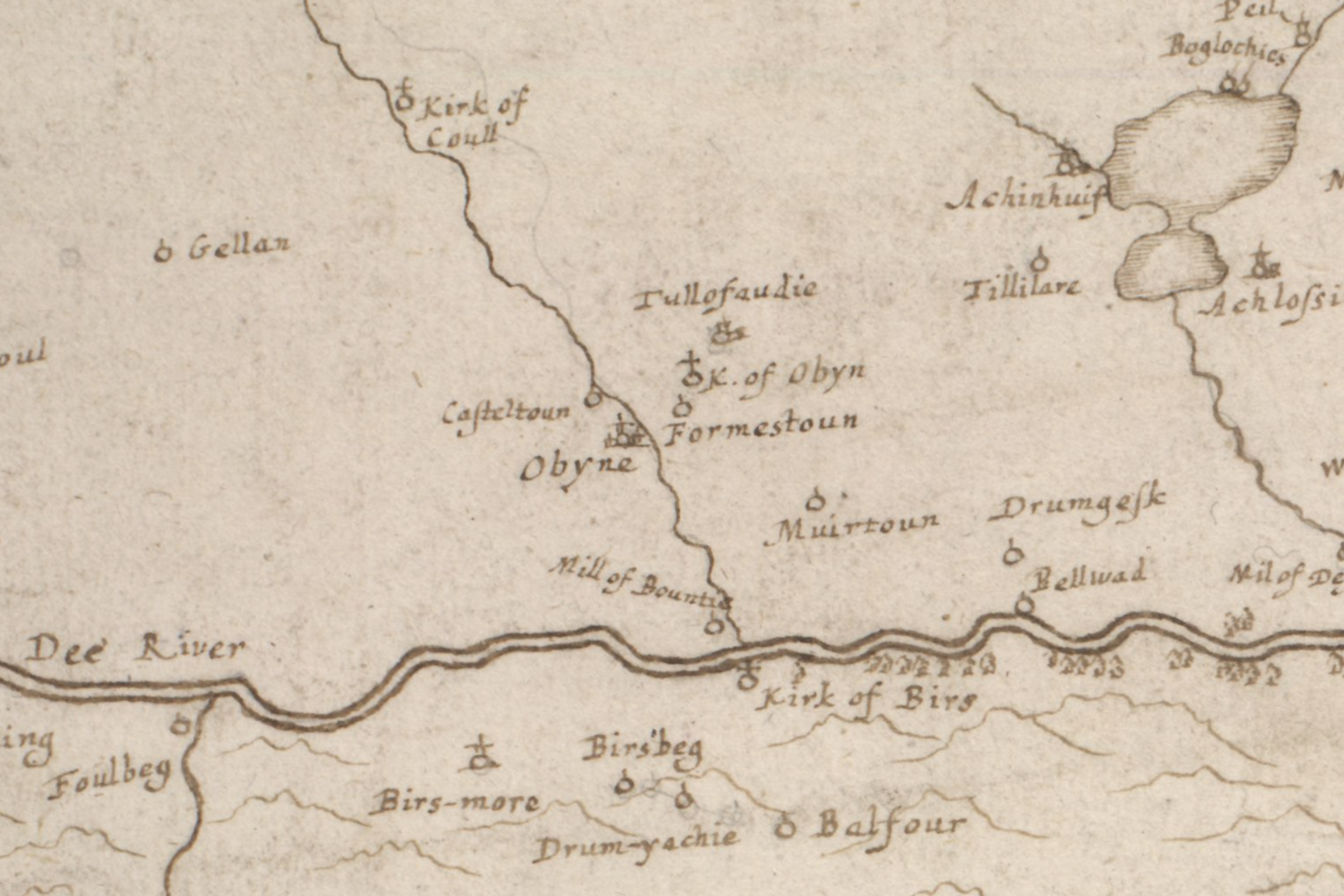

Of all the maps I’ve researched, this one expresses the least ambiguous geographic relationship between Aboyne, Formaston, and Kirkton of Aboyne, with the Tarland Burn clearly running between Aboyne and Formaston. This informs my theoretical distinction and placement on an evolving new map of the Aberdeenshire Poll Book. Mapmaker: Gordon, Robert, 1580-1661 Title: The draught of the Birs wt. the nixt parts of the river Dee. Date: ca. 1636-52. | National Library of Scotland
Anno Domini 1696 is a turbulent year for Scotland. Jacobites are unsuccessful in plotting the assassination of an unpopular King, William of Orange. In hopes of bolstering the Scottish economy, the Bank of Scotland opens for business, and the Education Act mandates a school for every parish in the country. Harvests fail yet again, creating a famine every bit as brutal as war, with perhaps a quarter of the population of Aberdeenshire eventually dying of starvation. And the infamous Robert Campbell of Glenlyon, commanding officer at the Massacre of Glencoe, dies penniless in Bruges.
The List of Pollable Persons within the Shire of Aberdeen, which we have been exploring, is indexed in this year, and efforts are under way to digitize it as a searchable database. As we’ve seen, it is a remarkable snapshot of a nation at a remarkable time in its history. In the Poll Book, the adult population is organized by locale at four scales: township, parish, presbytery (or district), and of course the shire or county level.
My first thought, of course, lead straight to visualization: what an amazing map this might create! What might we learn about life in general, or specific family lines, by making a visual expression of these places in a map? So I set about exploring the possibility.
Mapping parishes and presbyteries
We have to begin at some kind of beginning, of course, so we investigate what exists. There are non-contemporary maps at the parish level to be found at Genuki here and here. Genuki’s maps are based on OPR film numbers and seem to date from the mid-19th century, while another at Old Roads of Scotland seems to refer to the late 18th century, 100 years after the Poll Book. Perhaps because it is such a tiny country, maps at a granular local level abound — working with the map collection at the National Library of Scotland in combination with Genuki, one can find the position for the obscure Waulkmill, Burnside, or Kirkton which may no longer leave a trace on today’s maps.
So, generally speaking, we find there’s a gap in the visual expression of the Book’s data at the Parish and, especially, the Presbytery level — a project history has left up to me! Such a map will complement the data currently being digitized by my Canadian cousins, and it will assist in the quest to precisely locate any 1696 pollable Aberdonian listed therein.
Why is this needed? It was common practice for a community to name a building or small cluster of structures in accordance with the purpose it served — remember the Waulkmills, Burnsides, and Kirktons I mentioned before? There are hundreds of examples of such common, function-based nomenclature littered across the Scottish landscape to tease a researcher into a false lead. A person in Aboyne or Tough may have known it was “their” Kirkton when it was referenced, but a researcher distinguishing one from another needs at least parish level knowledge to do so, and the presbytery or even county level may be needed to distinguish a common place name like Craig.
And don’t even get me started on the orthographies! Milton, Milltoun, Milltown, Mill (of Wherever), Milne (of Wherever), ad nauseum. The variations within the Book even on the same page for the same place can be the biggest headache for a researcher. A map like this can tame the chaos. One learns that Birksbeg means Birsebeg, Keirn becomes Kearn, or Bottomend is Boddomend as one compares Book data to an OS map. My new map can list these variations together so that researchers can benefit.
Until such time as I can complete the task, I have created an imperfect temporary solution, synthesizing the above-mentioned parish maps into the map I present below, concocted from OPR information rendering the 1696 presbyteries: Kincardin, Garioch, Alfoord, Deer, Aberdeen, Ellon, Turriff, and Strathbogie, known so far. Presybteries in red represent those described in Volume 1 of the Book, those in orange Volume 2:
N.B.: This map was updated to reflect data in Volume 2, described in this post.
What is eventually needed is a comprehensive look at location names to correlate them with actual parish borders, which change over time, as we see comparing the Genuki and Old Roads maps. This is an effort I have only just begun to tackle. Those shifting parish borders will in turn alter presbytery borders, and we even see parish allegiances flipping between Aberdeenshire, Banffshire, or Kincardineshire over time. That will take a long time, and at the moment I only have data indexed for Volume 1, but I’m too curious to see what patterns might emerge when a one-name mapping exercise is done.
Mapping Cromars and Robbs
Actually, in my case, it will be a two-name study: the Cromars and Robbs. Perhaps this will provide some new insight into the origins of both lines. Here is a map based on this database index:
Orthographic variations such as Cromarr and Cromay (which may be incorrect) have been included for Cromar, while Robb variants include Robbie and Rob. We can see that the Robbs are more geographically dispersed, while the Cromars are found primarily concentrated in two close-knit groups.
Kincarden
The Presbytery of Kincarden, largest by area in Aberdeenshire, contains the southern Cairngorms and the area now known as Deeside, through which runs the River Dee. It contains the parishes Migvie, Tarland, Coldstone, Loggiemarr, Coull, Glentanner, Aboyne, Birss, Kincardin O’Neill, Lumphanan, Kindrocht, Crathie, Tullich, Glengairdine, Glenmuick, Midmar, Kinnernie, Echt, and Cluny. Many of these ancient parish names echo in current names: Logie Coldstone (Loggiemarr plus Coldstone) or Glenmuick Tullich and Glengairn (Glemuick plus Tullich and Glengairdine).
The largest number of Cromars and variants are found in Kincarden — 18 in all, including 1 record of a son. Of these, 10 are found highly concentrated within a 1.3 square mile area: 4 in Kirktoun, 3 in Formestoun, 1 in Bottomend, and 2 in Drumgask. As we’ll see, this cluster plays a particularly important role in my genealogy quest.
scroll tables on mobile »
| Pg | Surname | Name | Occupation | M | Family | Location | Parish |
| 44 | Cromarr | John | Servant | Meikle Gellan | Coull | ||
| 45 | Cromarr | John | Tenant | Yes | Meikle Gellan | Coull | |
| 57 | Cromar | Patrick | Tenant | Yes | Bottomend | Aboyne | |
| 58 | Cromar | Alexander | Tenant | Yes | son John, in familia | Formestoun | Aboyne |
| 58 | Cromar | Robert | Tenant | Yes | Formestoun | Aboyne | |
| 61 | Cromar | Issobell | Servant | Millne of Charletoun | Aboyne | ||
| 66 | Cromar | John | Tenant | Yes | Drumgask | Aboyne | |
| 66 | Cromar | Alaster | Servant | Drumgask | Aboyne | ||
| 68 | Cromar | George | Tenant | Yes | Kirktoun | Aboyne | |
| 68 | Cromar | Robert | Tenant | Yes | Kirktoun | Aboyne | |
| 68 | Cromar | Peter | Tenant/ Weaver | Yes | Kirktoun | Aboyne | |
| 69 | Cromar | Thomas | Tailor | Yes | Kirktoun | Aboyne | |
| 71 | Cromar | George | Tenant | Yes | Finzean | Birss | |
| 82 | Cromar | John | Tenant | Yes | Birksbeg | Birss | |
| 114 | Crommar | Francis | Tenant | Yes | Hillhead of Kincardine | Kincardin O’Neill | |
| 115 | Cromarr | Thomas | Servant | Mill of Kincardine | Kincardin O’Neill | ||
| 219 | Cromar | William | Servant | Upper Sachan | Cluny |
There are 7 Robbs, found in Birss and Kincardin O’Neill:
| Pg | Surname | Name | Occupation | M | Family | Location | Parish |
| 71 | Robb | Elizabeth | Servant | Bonoboth | Birss | ||
| 71 | Robb | Anna | Servant | Goukstyle | Birss | ||
| 73 | Robb | William | Subtenant | Yes | Whitestone | Birss | |
| 77 | Robbie | William | Grassman | Yes | his son, in familia | Inchboure | Birss |
| 87 | Robb | Francis | Servant | Kirktoun of Birss | Birss | ||
| 104 | Robbie | Alexander | Grassman | Yes | Mayns of Easter Beltie | Kincardin O’Neill | |
| 109 | Robbie | John | Servant | Wester Lernie | Kincardin O’Neill |
Alfoord
The Presbytery of Alfoord (modern Alford) is dominated by the River Don and is also known as Donside, the counterpart to Deeside paralleling it to the south. It contains the parishes of Alfoord, Lochell, Cushney, Keirn, Forbes, Keige, Cleatt, Tillinessell, Kinethmond, Kildrumey, Auchindor, Glenbucket, Cabrach, Kinbetach, Inverlochtie. Consolidation can be seen in today’s Leochel-Cushnie (Lochell plus Cushney), Auchindoir and Kearn (Auchindor plus Keirn), and Tullynessle and Forbes (Tillinessell plus Forbes). Orthographic evolution is easy to spot in today’s Clatt, Keig, and Glenbuchat, for example.
A respectably large line of Cromars, 9 in all, can be found in Alfoord, with 4 concentrated within a half square mile in Graystone, Kinstair, and Knowhead:
| Pg | Surname | Name | Occupation | M | Family | Location | Parish |
| 402 | (Unknown) | Cromar | Herd | Graystone | Alfoord | ||
| 409 | Cromar | Robert | Kinstair | Alfoord | |||
| 409 | Cromar | Margrat | Kinstair | Alfoord | |||
| 409 | Cromar | Isobell | John Marnoch, Weaver | Knowhead | Alfoord | ||
| 425 | Cromar | John | Servant | Ardgour | Touch | ||
| 425 | Cromar | Robert | Subtenant, no stock or trade | Mary Clerk | Tuloch | Touch | |
| 450 | Cromar | John | Servant | Balfoure | Forbes | ||
| 503 | Cromar | Jeane | Servant | Easter Clova | Kildrumey | ||
| 507 | Cromarr | John | Millart | Yes | Milne of Auchindor | Auchindor |
Four Robbs are found widely dispersed through the presbytery:
| Pg | Surname | Name | Occupation | M | Family | Location | Parish |
| 445 | Robb | William | Servant | Barflitt | Keirn | ||
| 447 | Robb | Jean | Robert Harvie, Shoemaker | Burnsyde | Keirn | ||
| 462 | Robb | William | Old Balgonen | Keige | |||
| 480 | Robb | John | Herd | Lethintie | Tillinessell |
Garioch
Another Donside district is the Presbytery of Garioch, containing the parishes of Leslie, Premney, Insch, Culsalmond, Rayne, Oyne, Logidurno, Daviot, Bethelnie, Bourtie, KeithHall, Kinkell, Inverurie, Kemney, Monymusk, and Kintore. Many of these survive, but very roughly speaking, Bethelnie partially overlaps today’s Old Meldrum, and the north half of Logidurno becomes Chapel of Garioch. Consolidation occurs in the case of the modern Keith-Hall and Kinkell, and there are other minor and obvious orthographic adjustments here and there.
Only 1 Cromar is found in Garioch, but as the map shows, this instance is about 5 miles distant from other Cromars in Alfoord:
| Pg | Surname | Name | Occupation | M | Family | Location | Parish |
| 387 | Cromar | Issobell | David Maclachlen, Miller | Westhaugh | Monymusk |
In contrast, a large cluster of 10 Robbs (including a pollable son) are found here, in orbit around the town of Insch in the same manner the Cromars do near Aboyne or Alford. We might conclude this area may be an origin for this line:
| Pg | Surname | Name | Occupation | M | Family | Location | Parish |
| 232 | Robb | William | Herd | Maynes of Lessly | Leslie | ||
| 233 | Rob | James | Subtenant/ Shoemaker | Yes | Maynes of Lessly | Leslie | |
| 243 | Robb | William | Shoemaker | Margrat Davidson | Milltoun of Barnes | Premney | |
| 250 | Rob | Alexander | Greinhall | Insch | |||
| 250 | Rob | Elspet | Hierom Gibb, Couper | Knockenbaird | Insch | ||
| 261 | Rob | Alexander | Grassman | Yes | Moss Syde of Polwhit | Culsalmond | |
| 263 | Robb | John | Tenant | Yes | Brankanenhum | Culsalmond | |
| 276 | Rob | John | Herd | Little Warthill and Cushiestown | Rayne | ||
| 280 | Rob | John | Tailor | Yes | son, George | New Rayne | Rayne |
Deer
If we don’t include Shetland, the Presbytery of Deer can boast the easternmost tip of Scotland. Parishes include Peterhead, Longside, Streichen, Deer, and Rathen. We find the parish of Deer separating into the modern Old Deer and New Deer, roughly speaking, and Streichen becomes Strichen and Buchan. This is one of the shiftiest borders to pin down in 1696, as chunks of Banffshire and Aberdeenshire are administratively reassigned over time. More research is needed, so as of this writing I’m indicating a district of Buchan described at Genuki as existing in the mid-19th century, but I’ve assigned it red to associate it with Deer and Volume 1 of the Poll Book. The map will be edited as research clarifies this confusing bit.
Cromars are quite rare in Deer, and even the one variant found may be incorrect. I need to find a source that would clarify if Cromay is a variant of Cromar or Cromarty. Perhaps this is even a common transcription error wherein a script r is mistaken for a y, so for now we’ll err on the side of inclusion:
| Pg | Surname | Name | Occupation | M | Family | Location | Parish |
| 571 | Cromay | William | Seaman | Barbara Barrack | no | Toun of Peterhead | Peterhead |
Robbs are plentiful in Deer, with a dozen including pollable children in orbit around Peterhead, so this area may represent an origin for another branch. This could be a false read, however, based on missing data in the presbyteries of Aberdeen, Ellon, Turriff, and Strathbogie. I’m aware, for example, of an enclave of Robbs near Auchterless, Turriff, midway between Peterhead and Insch. That data will be found in Volume 2 of the Book, still in progress for digitizing, so as the map updates with that information we may see the Peterhead cluster be absorbed into a larger, clearer pattern of dispersal:
| Pg | Surname | Name | Occupation | M | Family | Location | Parish |
| 553 | Robb | Gilbert | Tenant | Margaret Bodie | son, Alexander | Auchtiegall | Peterhead |
| 554 | Robb | John | Herd | Torterstoune | Peterhead | ||
| 555 | Robb | James | Servant | Scotsmilne | Peterhead | ||
| 559 | Robb | Christian | Servant | Myresyde | Peterhead | ||
| 560 | Robb | John | Smith | Margrat Prott | no | Blockhouse | Peterhead |
| 568 | Robb | John | Indweller | Margaret Erroll | no children pollable | Toun of Peterhead | Peterhead |
| 593 | Robb | Christian | Cairnbulg | Longside | |||
| 622 | Rob | Jean | Cottar wife | Smallburne | Deer | ||
| 635 | Rob | John | Tailor | Yes | sons, John and Alexander | Milne of Knock | Deer |
Methodology
The steps I used to create the Cromar-Robb map are as follows:
- Orthographic clarification | A process emerges out of a study of the sometimes wild orthographic shifts between sources and centuries. Some are clear by phonetic implication: Keirn becomes Kearn, for example. Others are quite more obscure: the relationship between Tuloch and Touch remains etymologically murky and needs further study. The place-name search function at Genuki works quite well once you have the orthographies sorted out.
- Map searching | Cross-referencing maps sourced primarily at Genuki and the National Library of Scotland, I find place location can be successful about 90% of the time. Some locations, like Easter Clova in Kildrumey and Scotsmilne in Peterhead, really resist pinning down. For tougher nuts, I peruse the ScotlandsPlaces website for clues. Where that doesn’t work, I conduct an exhaustive web search, finding everything from doctoral theses to modern real estate listings for breadcrumbs. These one-off sources are linked in the description for each place on the map.
- Deducing enclosure | How to deduce the area encompassing a place? This is certainly a soft science, and my conclusions may sometimes be debatable. Using OS maps from the mid-19th century, I compare the focal points of surrounding localities — usually structures associated with the names — and inspect the land use patterns surrounding them. I feel comfortable using non-contemporary sources here, because patterns of land partitioning are so persistent through the centuries, right up to today. Fields that are visually most logically associable with the named structure are assigned to it. This yields enclosures that average about 100 acres or about 2.5 square miles in area. In postal directories, we often see farmers described as working about 40-60 acres, so this implies more than one tenant per location, which can often be confirmed in the database.
- Listing data | Each place is named according to the orthography in the Poll Book, and the description contains:
- Names of tenants, spouses, family, and occupation
- Alternative and/or modern orthographic place name(s)
- Link to a Genuki map
- Links to other sources where Genuki is less clear
A new breadcrumb for Peter Cromar?
The frustration of the 1696 Poll Book is that it was indexed at a time when the gathering of consistent data was still an emerging practice. We don’t always see the name of a spouse, for example. More often, we simply see a “Yes” for a marriage notation. And since children and the indigent were not “pollable” persons, they don’t count as they would in a proper census (though a pollable child, one who has come of age, can sometimes be seen in the record). This can in part explain the mysterious lack of a young Peter Cromar in the data, though as we’ve mentioned before, John Henderson notes in his book Aberdeenshire epitaphs and inscriptions:
The Poll Book shows that in 1696 there were four persons bearing the surname of Cromar liviug in Kirktown of Aboyne, and the above Peter Cromar had doubtless been a son of one of them.
John A. Henderson
From the data, we can identify the four referenced by Henderson as George, Robert, Peter (a weaver), and Thomas (a tailor), so from Henderson’s assumption we infer one of these to be Peter Cromar’s father. This, however, is inconsistent with other theories we’ve encountered. In Peter Cromar 1690: parallel universes, recall that one common lineage asserted by several researchers suggests a Jhon or John Cromar, born 1670 in an unknown place, is the father of Peter. Many of those researchers claim Thomas Cromar, born in 1640 in Leochel-Cushnie, is Jhon’s father along with other sons Robert (1677) and James (1680), also born in Leochel-Cushnie (probably known as Lochell at the time).
Thomas (alternate Thomae) is claimed to have died in 1704 in Old Machar, thiry-odd miles to the east — not impossible, but somewhat suspicious. Some researchers also claim this to be the Thomas Cromarre who was caught consulting a sorcerer in 1672 in Lochell. But we know from experience that multiple instances of a Thomas and/or John might be misidentified as one person — and we’ll note that, at least as of 1696, there’s 8 John Cromars listed as pollable! So it’s anyone’s guess whether this is more than one Thomas, and if I’m a betting man, my money is on that probability.
The map helps us infer this. There is a large branch of Donside Cromars who Thomas 1640 could be a member of, independent of the Deeside Cromars (and if he did die in Old Meldrum, he may not show up in this database yet). The Deeside Thomas, listed in Kirktoun of Aboyne, would be a more likely candidate for Peter Cromar’s parentage. But what about the conflicting claims for the same concerning a Jhon or John?
Henderson assumes one of the Kirktoun Cromars to be Peter’s father, but he does not consider another possible relationship. What if one of them is Peter’s grandfather?
This fits nicely with a theory that synthesizes some of the claims made by other researchers. Assume Thomas the tailor, living in Kirktoun, has a son John (Jhon?) in 1670. By 1696, John is an adult tenant in Drumgask, less than a mile to the south of Kirktoun. John fathers a child, Peter, in 1690, who is too young to be counted as pollable. We don’t know the age of our Kirktoun Thomas, and we don’t know where he is born. But we know he is old enough in this theory to have fathered a child in 1670, so we can date him between 1640 and 1650. In 1692, the year of the Massacre of Glencoe, he’s middle-aged. Our Drumgask John is about 30 at that time, and Peter is less than 2.
Thomas would have been about 20 or 30 when John is born, and we know John to be 30 when Peter is born, so nothing in geography or time conflicts with the following question: could Thomas and John be father-and-son refugees from Glencoe who changed their identities and brought young Peter to Aberdeenshire?
We’ll investigate this new theory further in a future post.
Leave a Reply