Drone footage of Glencoe in winter | TourScotland
Part I of this mini-series explored the Massacre of Glencoe and its aftermath, including possible escape and migration scenarios that may have involved a very young Peter Cromar. Our goal was not to prove the migration, just to demonstrate it was not impossible. Here, we attempt to lean closer to plausibility, by broadly exploring the means that Highland folk had at their disposal to survive in the 17th century, a time of great change in Scotland. Below, we’ll explore aspects of the Highland environment, as harsh as it is beautiful, that contribute to our migration theory: shelter, clothing, survival gear, geography, weather, and travel infrastructure. This sets the table for the final post of this series, in which we’ll explore the theoretical migration itself.
Shelter
Highland domestic shelter reflected the social class of its occupants as much as it expressed the battle of survival in an inhospitable winter climate. In the case of the clan chiefs, highest in the social hierarchy, we see them constructing defensible homes — castles or keeps — distinguishable from the humble dwellings of the clan-folk under their charge. In Glencoe, we find the MacDonalds, whose chief, Alasdair Ruadh MacIain MacDonald, could not afford even a small keep, though one of his two homes was relatively more luxurious than those of his tacksmen (tenants), as described by John Prebble:
Maclain had no defensive keep, no black castle on an island like other chiefs. Of his house at Carnoch nothing remains, though the last stones were rolled into the river within memory. It stood below the Pap of Glencoe and, probably two storeys high, its walls washed with lime and its roof covered with blue slate from Ballachulish. Inside, its austerity was luxury compared with the cottages of the people, the light of torches and candles on un- draped stone, a council-room and rooms for privacy, books bought or stolen, a broad table for feasting, charter chests for papers and cupboards for fine cloths and foreign lace, glass to hold claret and a silver quaich for Maclain’s whisky.
Prebble, Glencoe: the Story of the Massacre, p. 28
Material characteristics
MacIain’s dwelling probably had a character and scale somewhere between the crofting-turned-hiking huts in Glencoe and a modest laird’s home like this one in Inverness.


2 | Lagangarbh Hut, a more “modern” crofter’s home, probably close in finish to Prebble’s description of MacIain’s dwelling: slate roof, white lime walls, though the skylights would not be present | Proper Adventure
3 | Abertarff House, a late 16th century construction with two habitable floors, is probably the same scale as MacIain’s house, but likely a more elaborate dwelling with its decorative crow-step turret | National Trust for Scotland
By comparison, the “cottages of the people” were purely an expression of survival against one enemy: the aggressively wet and cold climate. Prebble again, recounting the impresssions of English visitors to the Highlands:
However impressed … southerners were by the carriage of Highland men and the grace of the women, they were usually disgusted by the houses in which these heroic figures lived, comparing them to cow-byres, to dung-hills and the earths of wild animals. Crouching together on the slopes of the hills, the cottages appeared to be some strange fungoid growth, smoking with sickly heat. But they were built against the weather. Their thick drystone walls were less than the height of an average man, and above them was raised a roof-tree, covered with divots of earth and thatch held down against the wind by roped stones. Inside were comfort and protection for men, women, children and animals. Windows, where they existed, were glassless. A central hole in the roof, or at one gable, sucked up the draught for an open fire. Peat-smoke thickened the air, blackened the dry-stone walls, and red-rimmed the eyes of men and cattle. Each house was an expression of the people’s unity and interdependence. Each was built by all the township and in one day. As the stones were passed from hand to hand, the timber raised and the divots laid, the workers sang and told tales. At sunset the house was blessed, as much by sweat as by appeals to the saints or by charms placed at its door. A Highlander’s home was made from his land and was the foundation of his spiritual strength. ‘To your roof-tree!’ he said, wishing a man well.
Prebble, Glencoe: the Story of the Massacre, p. 28
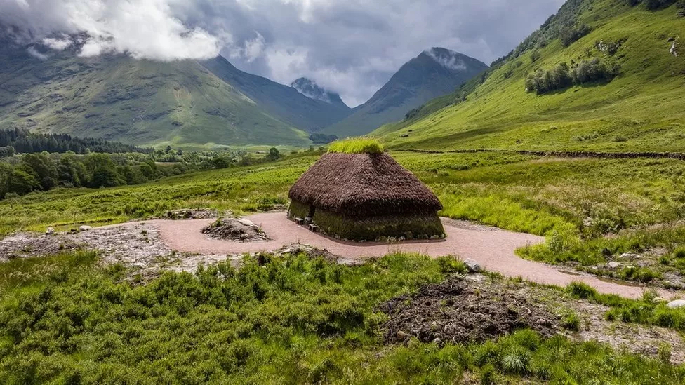
The creel house
While his historical documentary is a bit strained in its romanticism, Prebble’s account is accurate with respect to the dwellings we would find in Glencoe, with some variation in detail. We know from archaeology that some of the dwellings had stone foundations with thick turf walls, for example. A reconstruction of one of these turf houses, also known as a creel house or a tacksman’s house, was recently completed at the Glencoe Visitor Center.

As a former architect I find the drawing below to be as informative as it is hilarious, because these indigenous architects needed only the plan in their heads and the brawn in their muscles.

A second reconstruction
A very similar reconstruction at the Highland Folk Museum has been rendered in interactive 3D model form, which allows an exploration of the interior. You can take a deeper dive into the construction of the remarkable dwelling at Glencoe by visiting the resources in the notes below.
A tacksman’s house at the Highland Folk Museum, similar in scale and detail to the reconstruction at Glencoe. The main difference is in the stone walls at the Museum compared to the wicker-and-turf walls at Glencoe. | Highland Folk Museum
These were the humble homes that witnessed much of the carnage of the Massacre, and from which refugees escaped in terror. In our previous post, we demonstrated it is plausible that some folks may have understood hinted warnings from the soldiers quartered with them, and were able to prepare an escape the night before, while others were warned only by gunshots in the neighboring house as the tragedy unfolded. Few of them survived the blizzard conditions because they had to flee without preparation. But assuming some had time to do so, what would impoverished clansman be able to bring with them to survive a winter hike… possibly even an extended migration from Glencoe to Aboyne?
Fèileadh Mòr – the Great Kilt


1 | The palette key, with color definitions in hexadecimal values: DG Dark Green 002814; LR Light Red E87878; DR Dark Red 800000; DB Dark Blue 14283C; LB Light Blue 98C8E8
2 | The sett of said tartan, with given over a half sett and full count at the pivots as follows: DG8 LR2 DR8 DG4 DR78 LB2 DB36 DR12 DG60 DR4 DB4 LR2 DR14
3 | MacDonald of Glencoe tartan detailed at The Scottish Register of Tartans
The “traditional” tartan associated with MacDonald of Glencoe is listed with Scottish Register of Tartans, but like all official clan tartans found there, is a romantic Victorian conceit — an “invented tradition” as it were:
Details taken from a fragment of cloth in the West Highland Museum in Fort William and recorded as a “Piece of Old Hard Tartan, spun, woven and dyed by John Rankin, Glencoe, about 200 years ago.” When it was reproduced by D. C. Dalgliesh Ltd in the 1980s the firm attributed it to the MacDonalds with no proof other than the Glencoe connection.
The Scottish Register of Tartans
A practical garment
So it may come as a surprise to some that it’s highly unlikely to have found Alasdair Ruadh MacIain MacDonald and his kin sporting kilts in this tartan, but there is little doubt they would have worn some kind of great kilt (fèileadh mòr in Gaelic, also known as the belted plaid, pronounced played), with or without some kind of tartan weave, as their habitual dress. Today considered the most formal of formal dress, the great kilt at the time of the Massacre was a practical survival garment:
The garb is certainly very loose, and fits men inured to it to go through great fatigues, to make very quick marches, to bear out against the inclemency of the weather, to wade through rivers, and shelter in huts, woods, and rocks upon occasion; which men dressed in the low country garb could not possibly endure.
Duncan Lord Culloden Forbes, 1746
Imagine wearing cold weather survival gear from L.L.Bean at your next wedding! Yesterday’s Highland chieftain would be a bit surprised by the evolution of the kilt as we know it today. In his time, the fèileadh mòr was so simple, it was complex — a piece of cloth about 16 feet long and about 5 feet wide, it could be worn in a number of ways depending on the environment, as demonstrated by historical survival researcher Tom Langhorne at Fandabi Dozi:
The kilt, a year-round garment, became one of several layers in the fight for winter survival:
With such an outfit, a hardy 17th century Highlander could tough out an overnight winter hike:
Gear
But good multifunctional clothing is not enough. If one had sufficient time to prepare, one could gather a simple set of materials to help battle the elements. The 17th century Highlander was a master at traveling light. Here, Tom details his historically researched survival kit for starting fires, cooking, drinking, and other basics. In this video, we skip the first part about clothing and dive right into a discussion of knives, but if you want to watch the whole thing it’s available here:
With simple materials one can find in the environment, one could survive to travel long distances, such as MacIain had to do from Fort William to Inverary… perhaps even as refugees had to do from Glencoe to Aboyne.
Corries and Glens
Any escape routes out of the natural fortress of Glencoe’s mountains occurred in the corries and glens to the south. The inhabitants of Glencoe knew these well, and this local knowledge helped them to hide the cattle they rustled. It also helped them hide from the assault, though an unknown number of them died there of exposure. Those who were prepared for the elements, though, definitely had the home-field advantage: they would know how to escape undetected to Stewart-held lands in Appin to the south-west, Dalness to the south, and the area they used for summer shielings (temporary shelters for tending cattle) near boggy Rannoch Moor to the south-east. Not that it would be easy, but these people were tough and they lived with the land. Prebble describes the population and settlements in relation to many of these passages:
The greatest number of swordsmen sent to war by Clan Iain Abrach was a hundred and fifty, and from this it may be assumed that the population of the glen was rarely more than five hundred, and frequently less. The people lived in little townships between Achtriachtan and Loch Leven, at Carnoch on the mouth of the river where MacIain had his winter house, at Brecklet westward where Fingal slaughtered the Norsemen, at Inverrigan below Meall Mor, on the field of the dogs at Achnacone and at Leacantuim by the Cliff of the Feinn. The most easterly of the townships was on the loch beneath Aonach Eagach, although over Lairig Gartain in Glen Etive the tenant of Dalness and his people also acknowledged Maclain as their chief. The thickest settlement was at the entrance to Gleann Leac na Muidhe, creamy water and slopes as smooth as stone giving it its name of the Valley of Slate and Churn. Deep in the higher folds of Gleann Leac was MacIain’s summer home, where the hills hold back the wind and bright insects spin in the heavy heat. In winter it is a funnel of snow and the wind makes up for summer idleness.
The Land at Carnoch and in Gleann Leac was MacIain’s and his sons’. The tacks, the leases to the remaining townships were granted at MacIain’s will to others of his kin, all of them descendants of John of the Heather, and they paid their rents in kind or by bringing out their sub-tenants in arms when the chief demanded, when his summons flamed on Signal Rock. It was a cattle economy and a warrior society, and MacIain counted his wealth in those hundred and fifty fighting-men.
Prebble, Glencoe: the Story of the Massacre, p. 27
Let’s explore the potential of glens and corries adjacent to these settlements, and how they might function as escape routes. We’ll move from west to east along the south side of Glencoe. Our map of the Massacre from the previous post is here for orientation purposes:
Gleann ann Fhiodh | Glen Creran | Glen Ure
From Brecklett, several routes of escape are possible through Gleann ann Fhiodh. This valley can lead south-west to Steward settlements like Kentallan, Auchindarroch, or Duror, and possibly on to Appin or Castle Stalker further south. Tradition has it that Campbells who occupied Stalker actually sheltered Glencoe refugees, dispelling the myth propagated by a genocidal government that the Massacre was a clan affair. Another route from Gleann ann Fhiodh could connect over a ridge to Glen Creran or Glen Ure, leading south to small settlements at Salachail and Barnamuc. A third route could connect over a ridge to Gleann Leac na Muidhe, described in detail below.


Left | Path from Ballachulish in Gleann an Fhiodh | geograph
Right | Ruin and old gathering pen at Salachail in Glen Creran | geograph
360 view at Glen Duror Bothy, a path toward Auchindarroch in Stewart country | Google Maps
Gleann Leac na Muidhe / Fionn Ghleann / Gleann Fhaolain
This path led to MacIain’s summer residence, a site now home to Glencoe Mountain Cottages, which could have sheltered refugees. Gleann Leac na Muidhe could also have led across a ridge south-west to Salachail and Barnamuc. Crossing a ridge, refugees could head south-east via Fionn Ghleann or Gleann Fhaolain, leading respectively to Invercharnan or Inverellan in Glen Etive, discussed in detail below.


Left | Farm buildings in Gleann Leac na Muidhe | geograph
Right | Waterfall at the heights of Fionn Ghleann | geograph
Gleann Fhaolain where it intersects Glen Etive | Google Maps
Coire nam Beith
Birch Corrie is a short dead-end below Bidean Nam Bian, a taller peak defining Glencoe. Anyone escaping here would have a hard time finding another way out.
The path into Coire nam Beith | Google Maps
Coire nan Lochan
Bigger and deeper than Coire nam Beith, this corrie is nestled between two of the Three Sisters of Glencoe and offers better hiding, but is also a dead-end at a very high ridge.
Midway up Coire nan Lochan | Google Maps
Coire Gabhail | Lost Valley
This “Hidden Valley” was claimed to be a hiding spot for the cattle rustled by the MacDonalds, though it’s difficult to see how they managed to get the cattle into the large flat expanse between two of the Three Sisters. It’s often mentioned in accounts of the Massacre as a potential refuge for the fleeing MacDonalds, though it does appear to be a dead-end. Take a walk up the valley here:
Path into Coire Gabhail | Google Maps
But be aware it looked much more like this:
360 of Coire Gabhail in winter | Google Maps
Since it was likely a dead-end refuge, survivors either returned late on the evening of 13 Feb or stayed overnight in the cold. This is what such a venture is like today:
Lairig Etide | Dalness
The Lairig Etide contains a pass that could allow refugees passage to Dalness, if equipped well enough to handle the rugged terrain. Several sources claim it as a potential route.


Left | The entering the Head of the Lairig Etide | geograph
Right | Head of the Lairig Eilde: the north side of Stob Coire Sgreamhach, one of the Bidean nam Bian summits, overlooks the pass between Buachaille Etive Beag and Bidean nam Bian | geograph
Lairig Gartain | Dalness
Perhaps the least difficult crossing to Dalness and Inverellan, Lairig Gartain would have been the longest way around to shelter. It is often mentioned in accounts as a possible route.
Path in Lairig Gartain | Google Maps
Prebble claims Dalness as friendly to MacIain, so it along with nearby Inverellan could serve as a sheltered refuge.


Left | View from the path descending from the pass toward Dalness | geograph
Right | Inbhir-fhaolain (Inverellan) hut, built in the 1980s on the grounds of the original settlement | geograph
Weather


Glencoe during the big storms of Dec 2020, forecast well in advance of the event | The Scottish Sun
If the planners of the Massacre had modern weather forecasting at their disposal, they may have been able to select a better day to unleash their plot, as the morning of 13 February contained a nasty surprise in the form of a huge blizzard. A loss of mobility for troops traveling from Fort William down the Devil’s Staircase into the glen meant they arrived too late to close off the eastern end of the valley.
Alas for them, even the concept of a forecast was not a thing in the late 17th century. And while soldier and victim alike were crippled by the storm, the advantage may in fact have gone to the MacDonalds in this case. For those who withstood the exposure, the snow was both blessing and curse, though it was part of a larger weather pattern that had made their lives a struggle up until then.
Diarist accounts
For the decade of the 1690s was less than ideal, weather-wise. We know this not only from official record-keeping, which is unfortunately sporadic, but also because we can correlate stories in personal diaries. John Evelyn, a notable diarist of the period, habitually noted the weather in his writings. Though he lived in England, he made note of occurrences all over the land. At Britain’s WeatherWeb.net, his and other contemporary accounts are combined to create a history of weather. Of the decade, they collectively report:
… certainly contemporary reports relating to harvest failures, food shortages & extreme hardship right across these islands attest to probable sustained severe / inclement weather elsewhere – certainly for central and southern Scotland & much of Wales. As well as the depressed temperatures, there is strong evidence from various sources that, at least across northern Britain, there was a succession of wet spring & summer seasons, again compounding the problem of low temperature / poor growth of cereal and other crops. In Scotland in particular, the oat harvest is said to have failed on seven out of eight years.
WeatherWeb.net
The year of the Massacre, 1692, is especially harsh:
At the start of what was to become the sixth coldest year in the CET [Central England Temperature] record (mean value=7.7degC / around -2C anomaly on modern-day values), this winter had a CET anomaly of ~-2C on the ‘whole-series’ mean, and included a bitterly cold February, which, with a value of 0.0degC, was around four degrees C below the all-series (and modern-day) long-term average.
WeatherWeb.net
And John Evelyn probably confirms the presence of an “extraordinary snow” event in his diary:
[ February ] .. Freezing NE gale and heavy snow in Highlands ended mild, fair weather and brought renewed severe/wintry weather, as had held sway Dec 1691-Jan 1692, thereby providing cover for escapes from the Massacre of Glencoe
WeatherWeb.net
.
(Probably) Evelyn notes from London .. “an extraordinary snow fell” in February.
Advantage to the MacDonalds?
It’s interesting that the snow in this reportage is considered an advantage for the Massacre victims, proving “cover for escapes” which, if coupled with the advantage of local geographic knowledge, makes a good bit of sense. It also combined with an advantage of daylight. The MacDonalds had the cover of the darkness that held sway that awful morning. In Glencoe on 13 February, the morning twilight happens from 7:13 AM until sunrise at 7:52 AM, which means, as the first shots rang out as warning at 5:00 AM, there was nearly two hours of darkness before an inkling of dawn crept in, and even that was stifled by the cover of cloud and snow. One might have to read the land in some mad geographic version of Braille to get around, and if you were a solder from far away, you were pretty hopeless agains a more knowledgable local adversary.
The disadvantage would come later in the day, when the sun would set at 5:17 PM and twilight gave way to night by 5:56 PM, yielding a scant 9.5 hour of sunlight. This would give survivors who returned later in the day no light to find a scrap of order in the chaos of their burnt homes, nor would it provide a lot of light for an escapee to travel far, if they meant to leave Glencoe for good.
Nevertheless, sufficient time to prepare adequate survival clothing and gear, combined with superior knowledge of the lay of the land, advances the feasibility of such a migration beyond the not-impossible threshold we were striving for in our previous post. But where would this hapless forced migration lead? And how would one walk the Highlands during one of the worst winters in memory, with a baby in tow, no less?
Travel Infrastructure
By the time of the Jacobite defeat in 1745, Scotland was criss-crossed by an extensive network of roads constructed by the government specifically to allow the military to “tame” the Highlands. These military roads are documented in maps, many of which are carefully archived and indexed. General George Wade was a notable figure in the development of this infrastructure. But in 1692, these roads were just a twinkle in the General’s eye. What means was available to travel on foot at the time of the Massacre?


Left | Well-preserved section of General Wade’s Military Road near Melgarve. By modern standards crudely paved, these roads allowed relatively faster tactical mobility than the dirt foot-paths they were often built over. | Wikimedia Commons
Right | Hand-drawn between 1724 and 1745, General Wade sketched out A Map of Part of the Highlands, not done by actual Survey, but laid down on the common computed distances of places, a detail of which is here centered on Glencoe. The dotted lines represent new routes, such as between Glencoe and Fort William, perhaps replacing the cumbersome Devil’s Staircase that slowed troop movement during the Massacre | National Library of Scotland
Drove roads
Scotland had an economy based on agriculture and husbandry, and long before the military occupation and genocidal operations such as the Massacre and Highland Clearances, people needed to get crops and herds to market. The soil of Western Scotland supported cattle more than farming, so a network of drove roads connected places like Glencoe to Lowland cattle markets called trysts in the fall.


Left | Undated map of drove roads of Scotland, leading to trysts in Crieff and Falkirk | cateran’s common wealth
Right | Crossing the Ford, Henry Garland, artist’s rendition of a ford along a drove road | cateran’s common wealth
Blogger Haydn Brown discusses the earliest history of these drove roads:
As early as 1359 there is a record of two Scottish drovers being given letters of safe passage through England with cattle, horses and other merchandise and yet, for centuries, the trade of driving cattle to English markets did not flourish… . [T]he main reason was … any trade with England was actively prevented as it was seen as giving aid to the enemy. However, in 1603, James the Sixth ascended the English throne as James the First of England, uniting the two countries; by 1607, free trade had been agreed between the two.
This free trade agreement launched cattle droving to almost unimaginable heights, helped in no small way by the active discouragement of cattle rustling, or ‘reiving’. … Most [drovers] … conducted the business honestly and there was no doubt that droving would not have grown into a huge operation, which it did by the middle of the 17th century, without complete trust in those who took your cattle to market and returned with the money, whether it be honouring ‘bills’ or handing over cash.
In the lawless days of Scotland, cattle were the main source of a man’s wealth, obtained either by raiding or trading. The beasts were small and thrived on the hills, moorland and the intemperate climate which no doubt conditioned them for the future long drives to the English markets.
Haydn Brown, Drovers: Scotland to London via Norfolk!
The Glencoe men no doubt used this system for their cattle, both for droving and for the reiving that got them into so much mischief with neighboring clans as well as the government. As time went on, the roads slowly evolved. Architect Alexander Ross presented a paper on the topic of Old Highland Roads, in which he discusses how existing drove roads became the basis for some of Wade’s military roads:
During the latter part of the seventeenth century, large trade in cattle began to be carried on between Scotland and England … . In 1697 the matter came before the Privy Council, and “it was represented that between New Galloway and Dumfries there was no defined or made road. It was the line of passage taken by immense herds of cattle which were continually passing from the green pastures of the Galloway hills into England, a branch of economy held to be the main support of the inhabitants of the district, and the grand source of its rents.” Droves of cattle are, however, apt to be troublesome … . “Several debates have happened of late in the passage of droves from New Galloway to Dumfries. The country people endeavoured by violence to stop the droves and impose illegal exaction of money upon the cattle, to the great damage of the trade, whereby also riots and bloodshed have been occasioned … . The result of the petition was that a Commission was appointed by the Privy Council to make and mark a highway for drovers frae New Galloway to Dumfries … .”
These cattle raikes, as they are now called in the South, became common, and were so broad that cattle could feed by the way… . They are from 50 to 100 feet broad, with turf dykes on each side, and the track meanders along it … . These “rakes” are rapidly being curtailed and absorbed in the adjoining lands … .
These cattle tracks, which became common, and were in use from all parts of the North, literally gave the guiding lines to General Wade for his great system of military roads.
Alexander Ross, Old Highland Roads
Ross mentions “the Glenshee Road, from Castletown of Braemar” as one of those tracks. Now occupied by the A93 from Braemar south to Spittal of Glenshee, then from there to Enochdhu north of Kirkmichael by a footpath, the Glenshee Road was an an important track from western Aberdeenshire to the southern markets. As we’ll see in our next post, it may have been an important stage in a theoretical migration from Glencoe to Aboyne.
Footpaths
Many footpaths which are now used for recreation were based on ancient carriage-ways, postal routes, military roads, and drove roads. If one zooms in on a digital satellite map, one can easily see the lines of these paths snaking across the landscape. One of particular interest to a theoretical eastward migration is the Rannoch Moor Track, a path from Kingshouse lodge to Rannoch Station at the north head of Loch Laidon. Some or all of this track could have been used by our theoretical refugees to get to other established footpaths or drove roads along the west-to-east daisy-chain of rivers and lochs connecting Gaur to Pitlochry:

The dotted line running west to east from Kingshouse to Rannoch defines the Rannoch Track | The Stevenson Way
We’ll save speculation about the use of this or other footpaths for our next post in this series, but as serious, boggy, wilderness terrain, with a path or without, one would not attempt to traverse it under the best of conditions unless one knew the territory… or perhaps had genocidal troops nipping at one’s heels!
Next: we explore a virtual 17th century migration from Glencoe to Aboyne.
Notes and References
Shelter
National Trust for Scotland articles on progress for the turf house reconstruction:
- Re-creating a Glencoe turf house – the story so far
- Glencoe creel house construction underway
- Our Glencoe turf house is taking shape
Further online resources:
- John Prebble quoted liberally from Glencoe: the Story of the Massacre, available for checkout at Internet Archive
- Bringing Glencoe back to life with a replica turf house (paywall after first visit)
- Turf appeal to help rebuild Glencoe Massacre house
- Glencoe Turf House Reconstruction – Scottish Highlands, Glencoe – completed in 2022 (chatroom entry with good images)
- A Highland Home | The reconstruction at the Highland Folk Museum includes domestic items in the interior
The great kilt
- Highland Attire | An archive of the Historic Highlanders website
- Belted plaid
- Highland dress
- The Scottish Register of Tartans
Gear
Geography
- walkhighlands | website describing Highland tracks and paths
- AllTrails | website with trail information
Leave a Reply