YE loyal Macdonalds, awaken! awaken!
Mary Maxwell Campbell | Lament for Glencoe
Why sleep ye so soundly in face of the foe?
The clouds pass away, and the morning is breaking;
But when will awaken the Sons of Glencoe?

So, after around 30 journal entries exploring the origins of the Cromars in Aberdeenshire, and with all of that effort coming up hard against the brick wall that is Peter Cromar 1690, it’s clear we’ve exhausted that avenue of investigation for the time being. Others may see this journal and add other versions of Peter’s Glencoe escape to the three independent anecdotal instances that exist, but the chance now of finding a primary source that puts meat on the bones of that oral history is vanishingly small.
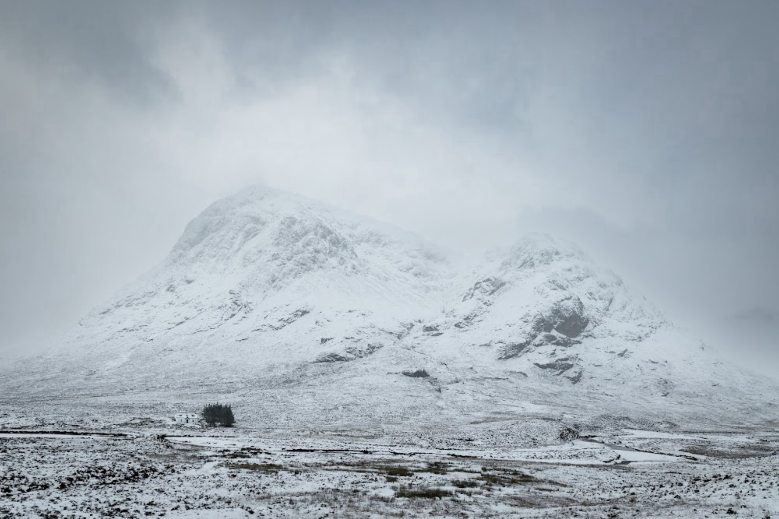
The Glencoe side of the riddle
If we are to do anything else with this riddle, we need another approach. Some have suggested DNA analysis as a way to crack the case, and this is indeed a promising tool, but it will take time and coordination among many collaborators. Until such time as that can happen, what can we do? Well, we know this riddle well enough as we travel along a reverse timeline from myself to the Kirkton of Aboyne … but what can we know about the Glencoe side of the riddle? What if we started in the distant past and moved forward with the arrow of time? Is there any hope that both timelines might point to the same hole in the record and help solidify — or debunk — the theory of a Glencoe origin story for our humble family?
First, a disclaimer: there will be no proof here.
We are only exploring the potential answers to a hypothetical question: what conditions would need to be satisfied for Peter Cromar to originate as one of the “Sons of Glencoe?”
Fittingly, we are nearing the 331st anniversary of the infamous Massacre. There is something very special about that number, actually: not only is it a prime number, it’s also a super-prime, a cuban prime, the sum of five consecutive primes (59 + 61 + 67 + 71 + 73), a centered pentagonal number, and a centered hexagonal number. If you are a numerologist, there is absolutely no better anniversary than this one to ponder the question!
Before the Massacre of Glencoe: origins of Clan Donald
Lords of the Isles

Clan Donald is one of the largest and historically most powerful Highland Clans. Its origins and history are recounted in detail by many reliable sources, and for those who are interested, I’m including links below. But it’s really beyond the scope of this post to repeat that history here, except to the degree it helps us answer our central question: whither the Cromars?
Traditionally, chiefs of Clan Donald enjoyed the title Lord of the Isles, a position that evolved from the King of the Isles, a title fit for a maritime kingdom that predated the Kingdom of Scotland itself. From about the 9th through the 13th centuries, the Kingdom of the Isles occupied islands of western Scotland, including the Inner Hebridean Isle of Mull, a gateway to Loch Linnhe and the region containing Glencoe.
Somerled
Gaels from Ireland were dominant in this region starting around the 4th century, and Vikings became an influential invading force, mixing with the Gaels from about the 8th century onward. This led to the rich Norse/Gaelic combination out of which emerged Somerled, the first of the Clan Donald Lords of the Isles. We can see this heady ethnic stew mix from the 10th through the 13th centuries as Somerled and the Vikings have their way in the map below.

Clan Donald held onto their title as a thorn in the side of the Kingdom of Scotland for centuries, until John II of Islay made an ill-fated alliance with England that led to his title being stripped by King James IV of Scotland, who took the Lordship of the Isles for himself (this is why Prince William is now the Lord of the Isles, instead of Godfrey Macdonald, the current and very elderly clan chief).
A grand genealogical chart
One can keep track of the clan in a stunning example of data visualization on display at the Glencoe Folk Museum: the remarkable Clan Donald Genealogical Chart drawn in 1814 by John Brown, a royal genealogist.

Image: Institute of Conservation Twitter feed
In the chart you can trace the Lords of the Isles from the Norse/Gaelic Somerled all the way to the ill-fated Alasdair Ruadh MacIain MacDonald, 12th chief of Glencoe. His name is Anglicized to Alexander on the chart:

Image: Institute of Conservation Twitter feed
Fascinating, yes, but how does all this help us understand the Cromars? For one thing, those Nordic/Viking/Gaelic roots leave their traces…
DNA clues
While the Vikings and Gaels were mixing it up in the west, the Picts were a fairly stable presence in the north-east, the area now occupied by Aberdeenshire. There were Viking raids for sure, but the Nordic foothold in Scotland was definitely in the west, not the east. One might expect several conclusions about the DNA makeup of a descendant of Aberdeenshire ancestors living far inland, but a significant presence of Nordic DNA would not be among them.
But in my case, there is Nordic DNA. Ancestry’s DNA analysis always had me flummoxed, because I’ve always had a pesky percentage of Nordic DNA for someone whose family has absolutely no connection to Nordic countries of any kind along any branch, maternal or paternal. Even as Ancestry’s DNA profile takes me on an ethic roller-coaster ride, with percentages rising and falling as they update their growing database, this genetic anomaly has persisted and even grown. This table shows how:
| Scot (Celtic) | Other Celtic | Nordic | Total | |
| 2022 | 40% (20-42%) | 3% (0-15%) – 1% (0-8%) Wales – 2% (0-7%) Ireland | 2% (0-11%) – Norway | 45% (20-67%) |
| 2023 | 38% (25-42%) | 6% (0-9%) – Wales | 12% (0-39%) – 8% (0-15%) Sweden, Denmark – 4% (0-24%) N. Germany | 56% (25-90%) |
There’s more. Ancestry now has the ability to display ethnicity inheritance by parent, even if they have not done a DNA analysis. Both of my parents passed away without doing this, but it’s clear from Ancestry’s data that nearly all this Scottish/Nordic stuff is coming from the paternal — that is, the Cromar — side. My maternal Cleaton side is significantly Sassanach, with minor nobility roots back to Clayton Manor in Lancashire — Normans perhaps, but Vikings and Gaels, never! This makes a stronger case that a Nordic presence in my results points toward a western isle Viking ancestor.
Is Nordic Germanic?
But there’s something questionable in this logic: what to make of the appearance of that Northern Germanic blood? Can I blithely just lump that into the Viking category? According to Karl Andersson at the website Nordic Perspective, the answer is yes. Karl explains:
What you may not know is that the Germanic people are all thought to have originated from a fairly small area in southern Scandinavia and northern Germany around the 4th century BCE, from where they set out on the Great Migrations around all of Europe and parts of Asia.
These migrations coincided with—and definitely contributed to—the fall of the Roman empire around the 6th century CE, some 200 years before the Vikings started their European raids and expansions from Scandinavia.
So the Vikings were definitely Germanic and spoke a Germanic language (Old Norse), but that doesn’t necessarily mean that they were culturally connected to all other Germanic groupings at the time. After all, they started raiding many of them and were considered barbaric heathens by most of them with little regard for any shared ancestry. [italics by me]
Andersson, Scandinavian, Viking & Germanic Links Explained (With Maps)
In other words, the cultures may have clashed, but the ancestry is common.

Map from Scandinavian, Viking & Germanic Links Explained (With Maps)
By this logic, if a portion of my DNA profile contains otherwise inexplicable paternal Northern German ancestry, it’s reasonable to conclude this could be a part of the Viking heritage of the western isles of Scotland. My profile, with about a 3:1 ratio between Celtic and Nordic strains, is consistent with ratios found in the Western Isle and North West Coastal Scottish populations. Published in the American Journal of Human Genetics, Agnar Helgeson et. al. present the following proportions of mitochondrial DNA (mtDNA) in their paper mtDNA and the Islands of the North Atlantic: Estimating the Proportions of Norse and Gaelic Ancestry:
| Population | Scandinavian | Gaelic |
|---|---|---|
| Western Isles | .115 (.025–.355) | .885 (.645–.975) |
| Skye | .125 (.025–.405) | .875 (.595–.975) |
| NW Scottish coast | .135 (.035–.355) | .865 (.645–.965) |
But how did this kind of proportion wind up in Aberdeenshire, far to the east of those populations, and presumably far less infused with Viking blood? One possible explanation is that someone migrated from the west to the east. Could that someone have been MacDonalds, sons of the Norse/Gaelic Lords of the Isles, fleeing the Massacre at Glencoe?
The Massacre of Glencoe

of Glencoe
The Massacre of Glencoe has been the subject of much scrutiny, from the rigged inquiry that exonerated King William to the historical drama authored by John Prebble. The notes below have many resources that can inform anyone unfamiliar with the event, one of the most notorious in a Scottish history filled to the gills with notoriety. Even so, this one stands out as particularly heinous. The sad history recounted at Murt Ghlinnhe Comhann – the Murder of Glencoe on the Glencoe Folk Museum site is both concise and relatively free of agenda.
Suffice to say, it did not end well for the MacDonalds of Glencoe. Thirty-odd members of the clan were gunned down before dawn on 13 February 1692, murdered by government forces for failing to meet a deadline pledging fealty to William and Mary, the monarchs who replaced the deposed King James in the wake of the so-called Glorious Revolution of 1688.
Easy prey
Although supporters of James, know as Jacobites, had basically been quelled by 1690, the government wanted to pacify Jacobite clan chiefs with a monetary bribe in return for swearing the oath of allegiance to the new regime. Even though the Glencoe chief, the aforementioned MacIain, was not the only chief who failed to meet the deadline, the relatively weak and lawless Glencoe clan became easy prey for a government that was intent on finding a clan to be made an example of.
Clan Campbell, arch-enemies of the MacDonalds, took the fall, but it was the government which manipulated long-standing clan rivalries as a cover for nothing less than an act of genocide made all the worse by violating the Highland code of hospitality. The Massacre was carried out by soldiers (only a few of whom were Campbells) quartered in the homes of the inhabitants of Glencoe, making these acts a particularly awful “slaughter under trust.”
Hints of impending doom
Tradition has it that many of the soldiers, conscripted Highlanders themselves, were disgusted by the proceedings and attempted to warn their hosts of the betrayal to come. One story in the oral history revolves around Clach Eanruig, or the Henderson Stone.

The Henderson Stone | Wikimedia Commons
Legend has it that a Campbell soldier, billeted with the MacDonalds and knowing about the orders to kill their hosts, sought a way to warn them. Instead of telling them in a manner which would have violated his military oath, he spoke instead to the Clach Eanruig, in words to this effect:
Thou grey stone of the glen, Though great is thy right to be in it, If thou but knewest what is to happen this night, Thou wouldst not abide here.
The legend says that his hosts understood the cryptic warning and escaped in the night, unable to warn their fellow clansmen.
Whether the story is factually accurate, it may contain this grain of truth expressed by John Prebble:
The Campbells of Argyll’s Regiment were Highland, and the inviolability of hospitality was as sacred to them as to any other clan, murder under trust was as great a sin. This is remembered in the stories which the Glencoe people told for another hundred and fifty years. Confused and contradictory though the legends became, they do record the truth that some of the Argyll men were revolted by the orders given them, and that within the oath of obedience they had taken they attempted to warn the people. … And for each warning remembered by the MacDonalds, there may have been another forgotten.
John Prebble, Glencoe: The Story of the Massacre, p. 219
A census by proxy
While some MacDonalds may have benefitted from these early warnings and were able to prepare for an escape in harsh weather, others were given less time, the only warning being the echo of gunshots in the predawn hours. Those with a head start had a chance at survival, but those who fled gunshots in the early hours were more likely to die of exposure in the corries and valleys to the south of the glen.
We don’t have a Census record for Glencoe in 1692, but researchers have been working on hypotheses about the population and what may have happened based on geography and archaeology. Derek Alexander, archaeologist with the National Trust, explains by referencing the six documented Glencoe settlements identified on William Roy’s famous military map of Scotland:
We can see there are eight buildings at Achtriachtan and the same again at Achnacon. There might even be evidence of an inn. You are looking at between 40 to 50 or 60 people living in the one settlement
“We know 30 were killed during the massacre but we don’t know how many died getting away. Once you start to look at the massacre from a landscape point of view you can plot the sequence of what happened and see how some people managed to get away, probably through the valley of Gleann Leac na Muidhe.
Archaeologists trace lost settlements of Glencoe destroyed after 1692 massacre
Assuming about 50 MacDonalds per settlement, and assuming the number of buildings on Roy’s map is an accurate enough proxy for a census, with 8 to 10 red dots representing structures at each settlement, the entire population of the glen was about 300, almost certainly no more than 400.
How many survived or perished in the snow is a matter of conjecture, but we do know survivors returned to mourn, bury the dead, rebuild, and try to gain the government’s peace. What is harder to discern is whether any left for good, perhaps to emigrate to Aberdeenshire.To test any theory as to whether this could have happened, we need a description of the aftermath, and a good map. Sadly, both are pretty tough to come by.
Mapping the aftermath


Timothy Pont | 13: Loch Eil Loch Leven Glencoe Nevis | The earliest known map of Glencoe with recognizable place names, circa 1590, a century before the Massacre.
It’s surprising that archaeological inquiries in Glencoe did not commence in earnest until very recently, but experts are attempting to fill in the gaps in the story before, during and after the Massacre. It’s equally surprising that a cartographic expression of these events has not really been attempted beyond the small map found in Prebble’s book. The archaologists at Achtriachtan, one of the lost settlements of Glencoe, are taking care of the story part. It falls to me to take care of the map.
Archaeology of Glencoe
There are several good articles describing the dig at Glencoe, all listed in the notes below. Focusing on three of the six settlements indicated by Roy — Achtriachtan, Achnacon, and Inverrigan — researchers have been able supplement the known record of events, mostly consisting of government correspondence and military records, with evidence from the victim’s perspective.
Achtriachtan has been particularly illuminating, being the best preserved ruin of the lot. Out of the 8 structures marked by Roy at the settlement, archaeologists were able to confirm the location of 5.


Top Left
Roy survey detail of Glencoe. Six settlements are clearly indicated with clusters of red dots: Inver Coen, Inverrigan, Achnacoan (spelled Acharigan by Roy), an unlabeled settlement which other maps indicate as Leckintyn, and Achtriachtan (spelled Achatrinchan by Roy). The presence of other townships on both earlier and later maps begs the question of Roy’s reliability, though his map is undoubtedly useful. For example, the 1689 map by Visscher indicates a Pooldavig, also called Polrig and Poll Domhain by other sources.
Other sources claim a Carnoch or Kernock as MacIain’s dwelling place. Another site, Carnochaise, may or may not be the same as Carnoch: the 1807 Arrowsmith map indicates them as separate, but this is more than a century after the Massacre. Brecklett, or Breckett, is indicated both by the OS survey map and mentioned by Prebble in his book. In short, the number of townships at the time of the Massacre could be as few as 6 or as many as 10. | National Library of Scotland
Top Right
Close-up on the township of Achtriachtan as drawn by Roy. Eight buildings are clearly marked in red. Five to the west are parallel to the slope, while three to the north and east are perpendicular. | National Library of Scotland
Bottom Left
Pattern of Achtriachtan structures confirmed by archaeologists in 2019. A solid red dot indicates a structure, while a red outline indicates an outdoor enclosure or pen. The pattern differs somewhat from the Roy map, in that one of the structures in the western half is clearly perpendicular to the slope. The enclosure to the north-east, however, fits nicely with the Roy pattern and may predict the presence of more undiscovered dwellings. Not every structure found by archaeologists is a home, however. One is a kiln, and it’s not yet clear if any of the roofed structures are purely agricultural in function. | The-Past.com
Bottom Right
A modern satellite view of the site. The old road is now a footpath, and the 19th century farm to the south sports some trees. The archaeological activity on the first structure adjacent to the old road is the bright rectangular patch at center, and the modern A82 highway is at the very bottom. | National Library of Scotland
Clarifying the aftermath
This new knowledge in combination with the old sources helps to clarify the aftermath. We learn that Achtriachtan was occupied by a cadet branch of the Glencoe MacDonald clan, tacksmen (tenants) under MacIain. Actual names of inhabitants can be discovered in documents relating to the Massacre, Jacobite muster rolls, parish records, and the 1841 census.
While we don’t know the names of everyone present at Achtriachtan on 13 February, we do know this tidbit: John MacDonald of Achtriachtan, a tacksman, went to stay with his brother at Achnacon on the night before the Massacre, taking a servant named Kennedy with him. John and his servant were killed at Achnacon, but his brother escaped. Meanwhile, soldiers at Achtriachtan shot some of their hosts, which alerted others in the township, who may have escaped via Lairig Gartain. This was possible because troops from Fort William arriving by way of the Devil’s Staircase in the snowy eastern mountains were far too late to block escape, but they marched on to despoil and burn the township. More details can be found at The Past website.
If they survived, where could refugees go? Remember that Clan MacDonald had made a lot of enemies through thieving and cattle-rustling from their neighbors, so that may have foreclosed on some options.
Refugees: geography and clan allegiances
To imagine how refugees may have survived and found shelter in neighboring townships, it helps to understand two phenomena: 1) the geography that limits mobility to passes, corries, and glens, and 2) the politics of clan relationships that may reveal allies and enemies, further determining paths of escape.
The natural landscape of Glencoe hasn’t changed radically over the centuries, but everything from Jacobite rebellions to the Highland Clearances to agricultural famines and urban industrialization created upheaval in the settlements, not only there but all over Scotland. To account for these changes and to try to pinpoint accurate positioning of the townships, roads, and rivers, and passes that would have set the stage for this human tragedy, I was able to function as an “armchair” archaeologist armed only with historical maps. A rich trove at the National Library of Scotland, detailed in the notes below, allowed me to work backward through time to find when (and where) settlements rose (and fell).
A map of the Massacre
Starting with the exquisite detail and precision of the OS Six Inch maps of 1847-53, I worked systematically back to the earliest map I could find, created by Timothy Pont a century before the Massacre. Along the way, I found military roads, footpaths, and even some rerouting of waterways that all help bring 1692 into better focus. The result is this synthesis of the research:
As you zoom in and out and click on landmarks and pathways, the timeline of events allowed by geographical (and meteorological) limitations becomes clear. We can see how feasible (or not) it was to attempt escape through various possible routes.
There’s more. We know that certain clans were rivals, and other were allies, and that this will also limit and permit certain probable routes. The record and oral histories combine to give only a vague picture of clan relations. We know that many, including the murdered MacIain’s sons, escaped into Stewart country in Appin, while others hid in Coire Gabhail or the Lost Valley. But to know more about these alliances and rivalries, we have to dive into clan history.
Allies and enemies
We know that the Glencoe MacDonalds had strong natural alliances with other MacDonald and MacDougal branches of Clan Donald, though the relationship to the MacDonalds of Keppoch to the north were sometimes riddled with internal clan politics. Nevertheless, we see them, along with the neighboring Clan Cameron, go up against Clan Mackintosh and their aillies in the Clan Chattan federation at the Battle of Mulroy in 1688. So with the aforementioned cozy relationship with Stewarts, there are good relationships to the north and east of Glencoe.
Unfortunately, the north is occupied also by Fort William, the nexus of hostile government forces, and the south is riddled with arch-nemesis Campbells, so the Glencoe MacDonalds are literally squeezed between enemies. Less clear is the relationship of Glencoe to the clans of the immediate east. The Menzies were Norman in origin, and the Robertsons, also known as Clan Donach, were descendants of the Lords of the Isles. Until further research allows a definitive call either way, we can assume the Robertsons were more inclined toward alliance based on shared ancestry, but we can safely wager both eastern clans were less hostile to the MacDonalds than the Campbells or the King.
Clan territories
It helps to understand the shifting alliances and property holdings of clans over time, but we do well to remember these territories are extra-legal, more like the “turf” of gangs or cartels in today’s world than formal recognized borders. So when perusing clan maps, it helps to keep that in mind.
Two useful maps in comparison on both sides of the Massacre timeline give a good sense of this, and may help us understand where refugees could have planned escape:


R | Map of the Highlands of Scotland denoting the districts or counties inhabited by the Highland Clans (1822) | National Library of Scotland
Let’s get a closer look using an overlay:


In the “older” map we see a long, skinny sliver of MacDonalds in Glencoe, wedged between Fort William enemies to the north and Campbell enemies to the south. Allies are close by to the east and west, Stewarts and Robertsons respectively. In the “newer” map the Glencoe clan is wider to the north and south but more narrow east and west. Immediate adjacencies of allies and adversaries have shifted borders a bit but are essentially unchanged.
Looking eastward
It’s when we look a bit farther afield that things get very interesting, if you are a MacDonald on the run and you feel the Highlands are no longer safe for you. Take a look at the holdings of Clan Farquharson to the east. In the old days, the Earl of Huntly to the north is Clan Gordon, neutral as far as we can tell. But later on, we see an admixture of Gordons, Forbeses… and Stewarts. If one were able to thread the needle and move through the Highland mountains, daisy-chaining friendly Robertson and Stewart holdings until one is far enough west, it’s conceivable that an ally awaits in Aberdeenshire.
An analysis of the contemporary network of roads and paths leads one to conclude that it is risky but feasible. Observe the long west-to-east passage indicated on the interactive Google Map above. There are some very rough patches along the way, to be sure.
Rannock Moor is a generally roadless, boggy wilderness for about a dozen miles, and the (at the time unimproved) military path that passes north from Spittal of Glenshee to Balmoral is another twelve mile uninhabited slog through the high Cairngorms. But for the rest of the way along Loch Rannoch and Loch Tummel, past the battlefield at Killiecrankie, from Pitlocry to Glenshee, and then finally from Balmoral to Aboyne, one can hopscotch from settlement to settlement, counting on the sacred Highland code of hospitality that was violated so savagely at the start of the escape. The majority of the 110 mile journey is not so hostile as one might assume — if one has allies to help.
A hypothetical migration
From DNA analysis to clan politics, we’ve explored several primary clues that might lead to a plausible hypothesis for a group of refugees to migrate from Glencoe to Aboyne:
Pros
- DNA evidence | The presence of Nordic genetic material in my DNA supports that portion of the hypothesis that requires an Aberdeenshire ancestor to have originated in the far west of Scotland.
- Early warning | A migration hypothesis is far less feasible in a situation where a refugee has little time to prepare for a difficult journey and could end up dying from exposure to the elements. Because there is evidence that some of the intended victims of the Massacre were provided with hints from reluctant soldiers, it’s reasonable to conclude our refugees may well have heeded just such an early warning, providing sufficient time to prepare and depart.
- Geography and infrastructure | A careful investigation of contemporary geography and road/path/settlement infrastructure reveals several ways to travel on foot from Glencoe to Aboyne. Most routes allow a hike of under 150 miles, a feasible if arduous distance.
- Clan politics | Not all roads are possible, however, due to animosity among clans. Overlaying geography with known clan relationships reveals that one of the west-to-east routes is particularly feasible — and this is in fact one of the shorter journeys, if not the easiest in terms of geography and infrastructure. That there are Stewart allies present at the terminus of the journey makes this all the more reasonable.
There are, of course, challenges to each of these points:
Cons
- DNA is not yet conclusive | We’ve only confirmed there is the possibility of a Viking correlation between western Scottish and Cromar DNA. We have not compared this to another group, such as DNA samples from native Aberdonians. Who is to say our assumption about the composition of eastern Scottish DNA is correct?
- Early warnings may not be sufficient | These are poor people living in a resource-deprived state. In the best of circumstances, one needs to be well-equipped to traverse the harsh landscape of Glencoe. Even if they did have early warning, did these refugees even have the resources to undertake such a trial?
- Infrastructure is hard to prove | Even with primary source evidence like contemporary and historical maps, it’s impossible to say whether the maps are accurate, precise, and complete. What if features exist that were not chosen to be illustrated, or what if there are extreme distortions in mapping distance or proportion?
- Clan relationships are… complicated | Like any family, clans have their internal struggles. Who is to say our assumptions based on a broad reading of history bear out actual alliances or rivalries? A good example of this nuance is illustrated by the trouble MacIain experienced when his kin, MacDonald of Keppoch, delayed passing on the announcement of James’s authorization to take William’s allegiance pledge by several crucial days in the week before the deadline. And all of this begs the question: why Aboyne? If the presence of an ally is important, there are several places along the way that avoid the trek across the high mountains.
Conclusion
Nevertheless, I’m confident the hypothesis moves our investigation forward. After all, remember: we are not out to prove a 2-year-old Peter Cromar MacDonald was carried across the Cairngorms by a desperate family. We are simply here to prove that such a journey, while improbable, is not impossible. In support of that alone, I believe this analysis may have succeeded in making the case.
Notes and References
Maps in chronological order
Working backward in time from today’s satellite imagery and more recent historical maps with much higher resolution, detail, and precision, we can trace the existence of settlements in Glencoe found on the earliest maps to create the most accurate map of the Massacre possible. One must pay attention to the loose orthography found in earlier maps, as well as shifts between English, Scots, and Scots Gaelic spellings. This strategy was used to create the live Google Map Glencoe Massacre and Aftermath above.
1104-1469
1587-94
- Thomas Brumby Johnston and James A. Robertson | Map of the clans of Scotland with the possessions of the Highland Proprietors according to the Acts of Parliament of 1587 & 1594 | Even though this map was created in the late 1890s, it uses information from the Acts of Parliament cited in its title to create a graphic expression of these ancient clan borders. Compare this to the map from 1822 below to get a sense of shifting power centers and alliances over time. We can see in this map the already compromised position of the Glencoe MacDonalds, wedged into the glen by its arch-enemy, the Campbells, to the south and east. Although we have allies Cameron and MacDonald of Keppoch to the north, a powerful enemy in Clan Mackintosh is found further north. We also find an ally in the Stewarts to the west. We are unsure of the status of the Menzies and Robertsons further east.
ca. 1590
- Timothy Pont | 13: Loch Eil Loch Leven Glencoe Nevis | Map by Timothy Pont, the earliest known map of Glencoe with recognizable place names.
1610
- John Speed | The Kingdome of Scotland | Though Latinized and low resolution, recognizable features around Loquhaber, Lorne, and Broad Albayn can be found.
1654
- Joan Blaue | Atlas of Scotland – Braid Allaban – Central Highlands | Pont’s work was instrumental in publication of this atlas with recognizable place names in Glencoe.
- Wikimedia Commons.
1689
- Nicolaes Visscher | Exactissima Regni Scotiae Tabula | The most contemporary map of the Glencoe Massacre with recognizable place names.
- Wikimedia Commons.
1746
- Thomas Kitchin | A map of the King’s roads, made by his Excellency General Wade in the Highlands | Though only broad regions and large settlements are labeled, this map shows footpaths and roads used by the military to “pacify” the rebellious Highlands. Presumably, the paved roads improved existing footpaths, while other unimproved paths found here would be improved in the near future, as we see on later maps.
1747-52
- William Roy | Military Survey of Scotland | Known simply as the ‘Great Map‘, the Roy Survey is a landmark cartographic achievement, providing a single uniform graphic expression of Scotland at a time beginning rapid change in the landscape. For many Highland settlements, including some in Glencoe, it is the only detailed map that survives for the 18th century. It had an important influence on the development of the later Ordnance Survey (OS) maps of Scotland below.\
1750
- James Dorret | A general map of Scotland and islands thereto belonging | Recognizable labels showing the evolution of place names.
1790
- Robert Campbell | A new and correct map of Scotland or North Britain, with all the post and military roads | One hundred years after the Glencoe Massacre, compare this map to the Visscher map above.
1806
- Daniel Lizars, publ. Thomas Brown | A travelling map of Scotland : including all the new and intended roads, bridges & canals, &c.: taken from the latest & best authorities | Paved military roads led to better traveling conditions and the publication of maps specific to non-military travel.
- Wikimedia Commons.
1807
- Aaron Arrowsmith | Map of Scotland constructed from original materials | Another travel map with recognizable place names and increasing precision over previous surveys.
1815
- John Thompson | Map of Southern Scotland | This map is contemporary with the conclusion of the first phase of the Highland Clearances.
1818
- John Pinkerton | Map of Southern Scotland | A non-Scottish contribution with extraordinary detail, printed in Philadelphia, my home town!
1822
- William Home Lizars | Map of the Highlands of Scotland denoting the districts or counties inhabited by the Highland Clans | Compare this map to the 1587-94 clan boundary map to understand the shifting and permeable nature of these extra-legal “borders.” The lines of demarcation are better understood as soft, fluid boundaries of influence, not at all like legal surveyed borders. Nevertheless, alliances among these moving but fairly stable spheres of influence can be used to construct a hypothetical logic for the migration proposed here. Supporting this, we note the presence of MacDonald allies, the Stewarts, in lands both west (in Athole) and east (in Aberdeenshire).
1832
- John Thompson | Northern Part of Argyll Shire | A much higher resolution atlas than his 1818 map, showing high level of detail during the height of the second phase of the Highland Clearances, just prior to the Highland Potato Famine.
1847-52
- Ordnance Survey (OS) Six Inch Map | The collective work and history of the Ordnance Survey is ongoing, but has its origins in William Roy’s strong advocacy for such a survey after the completion of his Military Survey above. The official founding date of the OS is 1791, but these highly detailed six-inch-to-the-mile scaled drawings are a testament to mid-19th century advances in survey technology. Stunningly detailed, these maps show the decline of some Highland communities after the second phase of the Highland Clearances, at the same time they become more connected through a growing network of railroads. Given the precision and wealth of detail found in this OS Survey, we use this as our starting point to work backward through the other maps and ascertain the location of important sites in the Massacre’s timeline, as well as a hypothetical escape route to Aberdeenshire.
Analysis
- A comparative list of Glencoe settlements on early maps | This database compares the presence of settlements on maps listed above, along with changes in their orthographies over time. It should be stressed that the absence of a particular settlement on a given map reflects the bias of the map-maker and/or the resolution of the map, and should not infer the actual presence or absence of the same. An example of this might be Brecklet, which shows up on early maps, disappears, then reappears in the 19th century. Having said that, in some instances, the sudden appearance of a place actually does recognize its historical creation. Kingshouse, for example, does not appear on a map until 1790, a century after the Massacre, because it was founded as an inn in the aftermath of the Jacobite rebellion of 1745 when the military roads were being built. Others, like Clachaig, also an inn, don’t seem to show up until the 1840s, even though it is founded in the 16th century and was therefore a witness to the Massacre. Some places seem to die and get reborn: such seems to be the case for Achatrinchan, one of the settlements despoiled during the Massacre. In short, this is a useful database, but it must be approached with some caution and sophistication.
Lords of the Isles
Further online resources to explore the origins of Clan Donald:
- Clan Donald Genealogical Chart – Podcast 4
- High Council of Clan Donald
- Fáilte a Chur Roimh an tir Chlainn Domhnaill Oighreachd
The Massacre of Glencoe
Further online resources to explore the Massacre:
- What They Don’t Say About the Massacre of Glencoe (video)
- First in a seven-part documentary from BBC, each about 6-9 min long (video)
- Docu-drama from the 1970s: wooden but not inaccurate retelling of the story (video)
- The Glencoe Massacre (podcast)
- Murt Ghlinnhe Comhann – the Murder of Glencoe
- Scottish History: The Glencoe Massacre
- The Massacre of Glen Coe
- Hell at Glencoe: what led to the massacre in the Scottish Highlands?
The Aftermath
Further online resources to explore the archaeology of Glencoe:
- Archaeologists trace lost settlements of Glencoe destroyed after 1692 massacre
- ‘A roof o’er their heads’: exploring the archaeology of Achtriachtan township in Glencoe (paywall after first visit)
- The dig uncovering Glencoe’s dark secrets
- ‘Lost Village’ Found at Site of Most Infamous Clan Massacre in Scotland
- 17th-Century Houseguests Slaughtered Hosts, and Archaeologists Are Investigating
Leave a Reply